Sunday, September 24, 2006

In Search of the Elusive Humpback


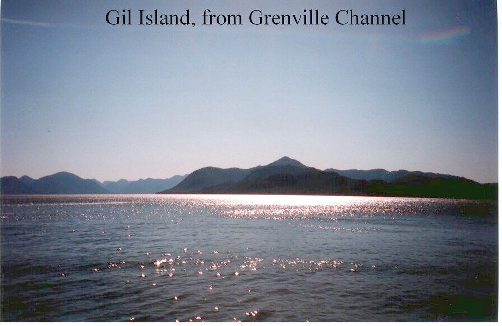
On the southern tip of Gil Island, a short boat ride from where the Queen of the North sank earlier this year near Hartley Bay, there exists a whale research station operated year-round by Hermann Meuter and Janie Wray. Alumni of Paul Spong’s Orcalab on Hanson Island, Hermann and Janie have been researching cetaceans, principally humpbacks and killer whales, full-time since 2002. This September I spent a fascinating week as their guests, getting to know the area, going out on the water just about every day, and helping to record whale songs from their acoustics lab.

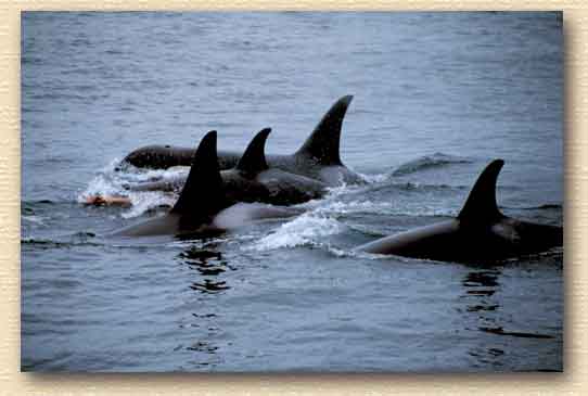
In the course of my very enjoyable stay, I was lucky to see several humpbacks and a few killer whales, plus two colonies of Steller sea lions, an elephant seal, and numerous Dall’s porpoises. And while I did not see the fabled Spirit Bear which roams nearby Princess Royal Island, other visitors to the region did. Nor did I see any wolves. But, what I did was many of the 64,000 returning pink salmon which returned to Gil Stream this year to spawn. I watched in utter amazement as the females desperately sought to lay their eggs in the stream bed, before breathing their last breath, as Janie patiently filmed the scene from the shore. Unfortunately, the number of pinks returning to other rivers and creeks in the region is way down this year.

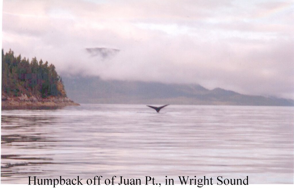
This is normally a good time of year for spotting and recording humpbacks in the area, as they bulk up on their way back down to Hawaii after a summer of feeding in more northerly climes. Of the estimated 20,000 humpbacks worldwide, roughly 5000 make the Northeast Pacific their summer residence. Of these, approximately 200 frequent the waters around Gil Island, including the appropriately-named Whale Channel, Squally Channel and Wright Sound. This fall, however, the bulk of the local population seems to have gone to some of the more inner channels, such as Ursula and Douglas, where Janie discovered more than a dozen individuals in recent days.

Cetacealab’s three sets of solar-powered hydrophones continuously monitor the sounds of the orcas and humpbacks – from Money Point in Wright Sound, Borde Island in Whale Channel, and just in front of Cetacealab in Taylor Bight. Hermann and Janie have a five-year record of the presence of these whales in the area – where they are, the kind of activity they are engaged in, what pod they are from, and their abundance. The value of their work is therefore incalculable; no one else is doing anything as remotely ambitious in such an out-of-the way, pristine though hostile environment.

Hermann and Janie eat, breath and sleep whales. Loudspeakers are wired throughout their cabin, which includes the acoustics studio and their living quarters. Thus, if the whales start singing during the night, the sound will undoubtedly wake the intrepid researchers, prompting them to get out of bed and run down to record them. There is even a loudspeaker outside their cabin, just in case they are not in the house when the singing begins.

Meuter and Wray also spend as much time as they can out on the water, looking out for the whales, and observing their behaviour up close and personal, as it were. In the summer, when the weather is good, they are out almost every day; in winter, they are lucky to get out one week in three. The rest of the time, they just tough it out in the comfort of their cabin cum research station, compiling statistics, catching up on paperwork, applying for research grants, etc.

Currently, there are two looming threats to the whales of the area, as well as to Cetacealab’s research program. One is a project called Batholiths, which, if approved, will entail three weeks of continuous seismic booms in and around Douglas Channel in the fall of 2007. The other is Enbridge’s Gateway pipeline and Kitimat tanker terminal proposal which, if it gets the green light, could see supertankers regularly transiting Wright Sound, Squally Channel and Whale Channel with their cargo of Alberta crude oil by 2010. Both of these projects pose significant risk to the health and existence of the whales, whether from the interference they will cause to their echolocation and feeding habits, or, in the case of the Enbridge project, from the oil spill threat.

If you would like to learn more about Cetacealab and the whales of Caamano Sound, and are concerned about the fate of the whales in light of the impending projects, visit the lab’s web site at www.cetacealab.org. Cetacealab is also a registered charity in British Columbia, which means that all donations are tax-deductible. Hermann and Janie heavily rely on public donations to pay for equipment, maintain the lab, and sustain their unique research program.

Tuesday, September 19, 2006

Gil Island Notebook


Hi, folks! Here I am, on the southern end of Gil Island, where Hecate Strait and Douglas Channel meet on BC's North Coast. This is the home of the humpbacks, and I am staying with my friends Hermann and Janie from Cetacealab.

Last Saturday we spotted two humpbacks while out on the water in appropriately-named Whale Channel. Yesterday we got as far as Squally Channel, on a beautiful, sunny calm afternoon. No whales were present, but the scenery was spectacular, with the steep sloping evergreen forests rising out of the translucent, deep blue sea. Magical! Our seaborne outing was followed by a hike up a boggy incline in back of Janie and Hermann's cabin, with stunning views from the summit over to the channel between Ashdown Island and Princess Royal Island, home of the Kermode, or 'Spirit' Bear, so named because of its whitish colour.

What impresses me most about this region, which is basically Caamano Sound, is its vastness and relatively-pristine state. When you are out on the water in Whale Channel, for instance, all you see is water, interrupted by islands and the hills and mountains that adorn them. There is next to no evidence of human presence on the horizon, in any direction.

This seemingly idyllic place is about as isolated as it gets. Sure, King Pacific Lodge is only a fifteen-minute boat ride away, and the Gitgat community of Hartley Bay perhaps an hour by boat. However, these two sites are themselves far from civilisation. And right here on Gil Island, which is about the size of Salt Spring Island in the Gulf Islands, our only neighbours are the whales ( humpbacks and killer whales, mainly ), the sea lions, the eagles, the spawning pink salmon, the wolves, the ravens and the black bears.

As I write this I have the headphones on, listening in on at least one humpback singing nearby the hydrophone at Money Point, near Hartley Bay. Hermann and Janie, who are both away this evening, leaving me in charge of the acoustics lab, tell me that it is quite unusual for the humpbacks to sing during their feeding sojourn in this part of the woods. Normally this kind of behaviour occurs only during the winter months, at their Hawaiian mating grounds. It is thought that the male humpback ( and it is only the male that sings ) could be getting in a bit of practice before the long journey south.

Janie and Hermann have been researching the distribution and habits of whales for the past four years. I will be filing further instalments of my experience up here in the days to come.

Saturday, September 09, 2006

Touring an Alaskan Supertanker


One fine day in the summer of 2005, I fulfilled a longstanding wish of mine - I toured an Alaskan supertanker. The Alaskan Frontier was in for repairs at a Victoria shipyard. Although she was only nine months old at the time, cracks had already developed in each of her two giant rudders. The largest of these cracks measured a whopping nine feet. The crack had been spotted by chance during a maintenance dive to check on another matter. Had the cracks not been spotted accidentally, a visual inspection of the rudder would not have been required for another four years - so much for stringent safety standards!

Checks on the Alaskan Explorer, sister ship of the Alaskan Frontier revealed three cracks on one of its rudders as well. Both vessels had been built in San Diego. The contract for the rudders had apparently gone to a German company, which then subcontracted to a Croatian firm. At the time of my tour, the ship's owners were negotiating compensation with the shipbuilders. One of the issues that had apparently arisen was whether the rudders needed to be replaced, or simply repaired. In the end, it seems they were merely repaired. However, the ship had to be taken out of service for several weeks, thereby resulting in a loss of income to the tanker's owners.

The Alaskan Frontier is owned by the Alaskan Tanker Company (ATC), which is a wholly-owned subsidiary of BP. She plies the Trans Alaska Pipeline (TAPS) route between Valdez, Alaska in the north and Washington State and California in the south. She is more than three football fields long, double-hulled, 185,000 DWT and capable of carrying 1.3 million barrels of crude oil in her tanks, putting her in the Very Large Crude Carrier (VLCC) class of tankers. This is the same class of tankers that Enbridge proposes to use on its Gateway tanker route out of Kitimat.

She has lots of backup systems in case of catastrophic failure: twin diesel-electric engines, twin props, and even twin engine rooms. She is basically designed to withstand the rough seas of the TAPs route, which present some of the wildest seafaring conditions on the worldocean. Her hull is meant to be flexible, so that she doesn't just break in two. Thus, while she was being repaired, and was therefore empty, there was apparently a one foot bend in her from bow to stern. However, when she is fully-laden the bend is thought to be around one or two inches.

Working on a tanker is a very dangerous job, and so every effort is made to ensure a safe working environment. Like all modern tankers, this supertanker has an inert gas system designed to prevent explosions from occurring in empty crude oil tanks. Also, a blast shield separates the cargo holds from the stern section of the vessel, where the bridge, accommodation and engine room are located.

Crews work a twelve hour shift - four on, four off, then eight on followed by eight off. They also must sleep during their eight hours off. Periodically they are rotated onto home leave for an extended period of time, during which time another full crew complement takes over. In contrast to older vessels, these modern ships require relatively few crew to run them; to keep costs down and avoid human error, everything that can be automated is.

When fully-laden, the crude oil on board is stored in a total of twenty cargo tanks. There are also segregated ballast tanks, so that when ballast water is discharged, it is not mixed with crude oil as in the bad old days of tanker operations. Another improvement relates to the cleaning of empty cargo tanks. In the past, these were washed with water, with the resulting wastewater/oil mix sometimes being dumped into the ocean. Now, the latest tankers, the Alaskan Frontier included, use a system called COW, for "Crude Oil Washing", whereby the tanks are washed with crude oil which is then recovered, recycled and reused, rather than discharged to sea.

The ship has twenty-four feet of freeboard, so that when fully-loaded, heavy seas do not come washing over the deck. There are also scuppers several inches high on the deck, to prevent any crude oil or other debris from washing overboard. The cargo oil pipes that one traditionally sees on the deck of a tanker are hidden to the naked eye, instead running below deck.

What the cracked rudders on this supermodern, spanking new behemoth demonstrate is that not even the most up-to-date technology can protect against system failure. In this case, disaster was averted by a chance dive that detected an enormous crack. But, what might have happened if the crack had gone undetected and perhaps grown over time? Would the ship's integrity have been compromised? Would one rudder have been sufficient, or would it, with its own cracks, have eventually failed as well? It's anybody's guess, but it does set off the alarm bells. The bottom line is, although risk can be minimised, it can never be eliminated, even with the best of intentions.

Shipping crude oil in extremely rough seas, day in and day out, year in and year out, is an inherently dangerous activity, and nature can take its toll on both crews and equipment. Tanker companies and the regulatory authorities alike have to be ever vigilant, imposing the strictest engineering standards, regularly inspecting for cracks and the like, and learning from experience. Beyond that, there is the societal question as to whether it is worth taking the risk transporting oil in such treacherous seas, next to such a fragile and remote environment as the Queen Charlotte Islands and Gwaii Haanas National Park Reserve, which is sometimes referred to as The Galapagos of the North. Is it worth risking the lives of the humpback whales that are currently feeding in the area, or the killer whales that call this region home? Does Enbridge's promise of a tug escort in confined channels along the proposed Gateway supertanker route eliminate the risk, or merely attenuate it?

These are just some of the questions facing communities as they come to terms with the prospect of VLCCs regularly plying the waters of Douglas Channel, navigating past Hartley Bay and Gil Island, where the Cetacealab whale research lab is located, and eventually out into Hecate Strait, Dixon Entrance, Queen Charlotte Sound and points beyond.

My tour of this behemoth, which is still relatively small by international tanker standards, ended with lunch in the cafeteria with the Captain of the Alaskan Frontier, Ralph Torjusen, a native of Manhattan. Many thanks to him and to Mr. Anil Mathur, President of ATC, for allowing this informative tour to take place.

Friday, September 01, 2006

BC Marine Environmental Policy Papers Made Available

A total of eleven written submissions by Dr. Gerald Graham to various public consultation processes related to marine environmental policy on the wet coast of Canada are now available. Topics covered include the:

1) Deltaport Third Berth Expansion Project Comprehensive Study
2) BC Offshore Oil and Gas Moratorium Panels (3)
3) Southern Resident Killer Whale Draft Conservation Strategy (2)
4) Southern Strait of Georgia National Marine Conservation Area Feasibility Study
5) Marine Mammmal Regulations Initiative
6) Scott Islands Marine Wildlife Area Initiative
7) SETAC Panel Victoria Sewage Review
8) COINPacific Forum
9) Batholiths Project ( work in progress )
10) Critique of Enbridge Gateway Environmental and Socio-Economic Assessment Consultation Process ( work in progress )

Submissions range in length from one page to fourteen. They are available either individually or as a CD set.

A complementary sample of Dr. Graham's work can be seen in the next blog entry, on the topic of the Deltaport Third Berth Expansion Project.

Deltaport Expansion Imperils Orcas


Introduction

Fisheries and Oceans Canada’s 2005 comprehensive study of the Deltaport Third Berth Expansion Project concluded that “(T)he potential cumulative effects of additional vessels visiting Deltaport is likely to be negligible” ( P. 179 ). It is the contention of this submission that the conclusion reached by the DFO study is based on incomplete information as well as an incorrect interpretation of data that is available.

What the study looked at and determined

The DFO study looked at the impact of increased ship movements to and from the expanded Deltaport terminal, as well as from the entirely new, second terminal which is expected to be operational by 2021. These movements are anticipated to increase as follows:

• From 3.1 ship movements per day in 2003 to 3.4 when the third berth addition to the existing terminal is in operation.
• Up to 5.3 ship movements per day when the second terminal is in operation in 2021 ( P. 179 ).

The study correctly noted the recent trend towards larger container vessels being used ( P. 179 ).

The study conceded that “(T)he project will introduce some additional residual effects of noise and collision risk from additional ship visits” ( p. 179 ) Nevertheless, the study concluded that given the

“…low quantity of vessels and the slow speed… from existing and projected future vessels visiting Deltaport, compared to other vessels in the Strait of Georgia, the collision and noise risk to marine mammals is considered to be negligible.” ( P. 180 )

Deficiencies in the study

The author takes issue with this conclusion, basically on four grounds:

1. The increase from 3.1 ship movements per day to 3.4 and then 5.3 is significant, not insignificant. Similarly, the increase in the risk of collision and the noise risk to marine mammals will not be insignificant.
2. The study fails to consider the increased threat of oil spills presented by an increase in ship movements. The increased threat level this represents to the endangered southern resident killer whales is significant.
3. The study only considers the impact of increased ship movements in the Strait of Georgia, whereas it should be looking at the impact of these ship movements in Boundary Pass, Haro Strait and the Strait of Juan de Fuca, all of which form part of the core habitat for the southern resident killer whales of the area.
4. The project has, it seems, not been TERMPOLed.

Let us examine each of these points in turn.

The increase in ship movements is significant

An increase from 3.1 to 3.4 ship movements per day may not seem like much, but it is actually an increase of 109.5 ship movements per year through one of the world’s busiest shipping lanes. What is more, we are talking here about what are generally very large vessels – vessels that are getting larger and larger each year.

Furthermore, an increase from 3.1 ship movements per day today to 5.3 ship movements per day fifteen years from now would represent an increase of 803 ship movements per year, which by any yardstick is a very large increase in transits. In short, the increase in ship traffic is likely to be considerable rather than marginal, with potentially significant increases in collision risk, noise risk and ship strike risk to marine mammals as well.

The threat of oil spills is significant

For some inexplicable reason, the comprehensive study only looks at the increased threat posed by noise and ship strikes. While these are no doubt important threats, so is that posed by oil. The oil spill threat comes not just from tankers but from the fuel on board cargo vessels.

It is generally recognised that oil spills represent one of the principal threats to the survival of southern resident killer whales, which are on both Canadian and American endangered species lists.

The environmental threat of increased shipping extends well beyond Georgia Strait

Again, for some unknown reason, the comprehensive study only looks at the threat posed by increased shipping in the Strait of Georgia, i.e. the body of water in the immediate vicinity of the project site. While undoubtedly significant, the entire commercial shipping route to and from the Pacific Ocean, in and out of Deltaport should be taken into account. This route includes, from west to east, and in addition to Georgia Strait, the Strait of Juan de Fuca, Haro Strait and Boundary Pass. Taken together, these four waterways constitute the core habitat of the endangered southern resident killer whales. In fact, for much of the year large cargo ships navigate in very close proximity to the whales, particularly in Haro Strait on the American side of the border, close to San Juan Island. Significantly, part of this region, particularly around Boundary Pass, is being considered by Canadian authorities for designation as a National Marine Conservation Area.

Within each of these maritime areas, a significant increase in the level of commercial shipping activity can be expected to increase the amount of noise the killer whales are subjected to. The risk of collisions, ship strikes and oil spills will also necessarily increase.

What ever happened to TERMPOL?

Transport Canada is supposed to apply the TERMPOL review process whenever a new berth is being built along the coast. TERMPOL is expected to be implemented in respect of the anticipated Gateway project which Enbridge is considering for Kitimat. Thus, why not for Deltaport expansion at Roberts Bank? While TERMPOL principally applies to terminals handling bulk oil, natural gas and chemicals, it can be applied to other cargoes as well. Given the presence along the proposed shipping route of southern resident killer whales, a Species at Risk Act-listed endangered species, and the significant threat to them posed by oil spills, one is hard pressed to see how the Minister of Transport could refrain from applying the TERMPOL process in this instance.

Conclusion

Contrary to the bold assertion in the comprehensive study to the effect that the effects of increased shipping related to the Deltaport expansion are likely to be minimal, this critique humbly submits that the cumulative effects of this long-term project are potentially catastrophic in respect of the southern resident killer whales which frequent the area used by ships entering and leaving Deltaport.

DFO’s comprehensive study completely ignores the fact that Deltaport shipping traffic will traverse, on a daily and continuous basis, year in and year out, the core habitat for these same whales, and that Environment Canada is considering the establishment of a National Marine Conservation Area in an area that encompasses the major shipping channel of Boundary Pass.

Already subjected to a number of stressors, including noise, ship strikes and the threat of oil spills, as well as the lack of prey and environmental contamination, the significant increases in ship traffic associated with the Deltaport expansion could sound the death knell for this icon of the Pacific Northwest. One need only look to Prince William Sound, where the 1989 Exxon Valdez oil spill virtually wiped out one local pod of orcas, for an example as to what might happen.

For all these reasons, at the very least, the authors of the comprehensive study need to go back to the drawing board, demonstrate that they are aware of these significant threats, and indicate what steps are planned to mitigate the negative effects associated with them. Only by doing this can their study be worthy of the designation ‘comprehensive’.